
Xianyang was the capital of China in the Qin dynasty. It is a prefecture in modern-day Shaanxi province, on the Wei River, and is located a few kilometers upstream (west) from Xi’an. Integrated into the Xi’an metropolitan area, one of the main urban agglomerations in inland China, with more than 7.17 million inhabitants. It is known as the China’s first capital and is a very significant city.
Guigang 贵港
Guigang “Distinguished Harbor” is a prefecture-level city in eastern Guangxi. It is located between Guangxi’s five major cities: Nanning, Guilin, Liuzhou, Beihai, and Wuzhou. Its location makes it a major transportation and business hub, connecting central China with the south, especially Hong Kong and Macau.
Guigang’s population is 4,400,000, mainly Cantonese Chinese along with a number of minority tribes.
Leshan 乐山
Leshan is a prefecture-level city located at the confluence of the Dadu and Min rivers in SichuanProvince, China. Leshan is located on the southwestern fringe of the Red Basin in southern Sichuan, about 120 km (75 mi) from Chengdu. Its population was 3,235,759 whom 662,814 lived in the built-up (or metro) area.
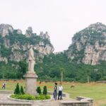
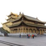
Mount Emei Scenic Area, including the Leshan Giant Buddha, the largest stone-carved buddha in the world. There are many Yi people living in this area. They are one of China’s minority peoples.
Wuwei 武威
Wuweia is prefecture-level city in northwest central Gansu province. In the north it borders Inner Mongolia, in the southwest, Qinghai. Its central location between three western capitals, Lanzhou, Xining, and Yinchuan makes it an important business and transportation hub for the area. Because of its position along theHexi Corridor, historically the only route from central China to western China and the rest of Central Asia, many major railroads and national highways pass through Wuwei.
Population 1,815,054. Urban: 509,600 with 38 ethnic groups represented including Han, Hui, Mongol, Tu, Tibetan, etc
- « Previous Page
- 1
- …
- 3
- 4
- 5
- 6
- 7
- …
- 11
- Next Page »